如何使用Python获取城市的经纬度?
要获取城市的经纬度,我们将使用 geopy 模块。 geopy 使用第三方地理编码器和其他数据源来定位地址、城市、国家等的坐标。
首先,请确保 geopy 模块已安装-
pip install geopy
在下面的示例中,我们将使用 Nominatim 地理编码器来找到城市“海得拉巴”的经度和纬度。
步骤−
- 从 geopy 模块中导入 Nominatim地理编码器 。
-
初始化Nominatim API,并使用 geocode 方法获取输入字符串的位置。
-
最后,通过 location.latitude 和 location.longitude 获取位置的纬度和经度。
示例1
# Import the required library
from geopy.geocoders import Nominatim

# Initialize Nominatim API
geolocator = Nominatim(user_agent="MyApp")

location = geolocator.geocode("Hyderabad")

print("The latitude of the location is: ", location.latitude)
print("The longitude of the location is: ", location.longitude)
输出
它将在控制台上打印以下输出 –
The latitude of the location is: 17.360589
The longitude of the location is: 78.4740613
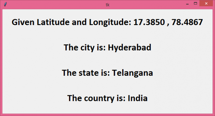
在这个例子中,让我们做 Example 1 的反面。我们将先提供一组坐标,然后找出这些坐标所代表的城市、州和国家。但与在控制台上打印输出不同的是,我们将创建一个 tkinter 窗口,其中包含四个标签来显示输出。
步骤 –
- 初始化 Nominatium API。
-
使用 geolocator.reverse() 函数并提供坐标(纬度和经度)来获取位置数据。
-
使用 location.raw[‘address’] 获取位置的地址,并遍历数据以找到城市、州和国家。
-
在 tkinter 窗口内创建标签来显示数据。
Example 2
from tkinter import *
from geopy.geocoders import Nominatim

# Create an instance of tkinter frame
win = Tk()

# Define geometry of the window
win.geometry("700x350")

# Initialize Nominatim API
geolocator = Nominatim(user_agent="MyApp")

# Latitude & Longitude input
coordinates = "17.3850 , 78.4867"

location = geolocator.reverse(coordinates)

address = location.raw['address']

# Traverse the data
city = address.get('city', '')
state = address.get('state', '')
country = address.get('country', '')

# Create a Label widget
label1=Label(text="Given Latitude and Longitude: " + coordinates, font=("Calibri", 24, "bold"))
label1.pack(pady=20)

label2=Label(text="The city is: " + city, font=("Calibri", 24, "bold"))
label2.pack(pady=20)

label3=Label(text="The state is: " + state, font=("Calibri", 24, "bold"))
label3.pack(pady=20)

label4=Label(text="The country is: " + country, font=("Calibri", 24, "bold"))
label4.pack(pady=20)

win.mainloop()
输出
它将产生以下输出−
 极客笔记
极客笔记